When you learn to drive a vehicle on the road, a compulsory element is to learn road signs. Similarly, if you are learning to sail then it is really important to know your buoyage markers too. These are the highway signs for the sea!
Buoys are noted on your navigation charts using symbols which show colour, shape, and light characteristics. They may have a name or number too. A buoy is a floating object which will be anchored to the sea bed or the object it represents.
Know Your Buoyage
We’ve put together a quick overview of some of the main buoys you may see out on the water. This is also a great reminder for experienced skippers too. If you would like an in-depth guide to buoyage then check out the RYA’s great selection of training materials below:
RYA Navigation Handbook 2nd Edition
“Cardinal Marks” by Denelson83 – Own work. Licensed under CC BY-SA 3.0 via Wikimedia Commons
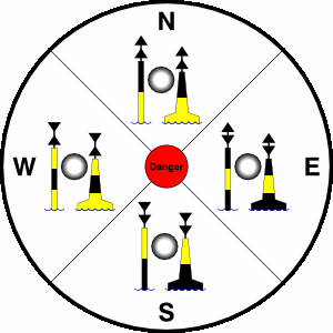
Cardinal Marks
Cardinal Marks are there to direct you to the safest deep water from the mark. For example, if you see a West Cardinal then you should navigate west of that mark. They may also indicate the safe side to pass a known navigational danger. Cardinal marks can be identified by:
- Their distinct black and yellow striped design. This correlates to the direction in which the mark points. Example: The black mark on the South Cardinal is at the bottom.
- The direction the two conical top marks point towards. Example: North is both conical marks pointing upwards.
- The sequence of flashing lights. The lights flash Fast or Very Fast and indicate the direction by the number of flashes which correspond with a clock face. Example: West is nine flashes.
Port & Starboard (Lateral) Marks
These are the most common buoys you will see as they mark the outer edge of a channel. There are two zones called IALA (A) and IALA (B) and it depends on where you are in the world as to which one applies.
Across most of the world, including UK and Europe, the IALA (A) is used. However, in places such as North, South, and Central America we use IALA (B). The IALA (A) shapes are red squares (with red lights) marking the port side and green cones (with green lights) marking the starboard side. The shapes/lights of the marks are the same internationally, although which side they mark is opposite. Make sure you check your charts to know which region you are sailing in.
wikipedia.com
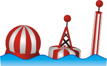
Safe Water Marks
Safe water marks are very distinctive with red and white vertical stripes and a ball shape on top. They emit a single long white flash every 10 seconds. Safe water marks are surrounded by deep water and act as the waypoint between open ocean sailing and pilotage into a shallower area. These marks are also known as “Fairway Buoys”.
http://www.gnu.org/copyleft/fdl.html
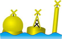
Special Marks
If you come across a yellow buoy (any shape) with a cross on top, then you have found a special mark. It may be lit by a yellow light. Special marks often indicate special features such as swimming areas, fish farms, anchorages, historic wrecks, or firing ranges. They are never used to mark navigational hazards.
“IALA isolated danger”. Licensed under CC BY-SA 3.0 via Wikimedia Commons
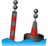
Isolated Danger Marks
Isolated danger marks indicate a hazard to navigation and shipping. They can be any shape or size but always have black and red bands and two black balls situated on top. The hazard will be a small solitary hazard such as submerged rocks which can be easily navigated around.